


Ok, ok. You know the view. But do you know the story?
Tracing the rugged ridgelines and bluffs above Harpers Ferry, the Maryland Heights Trail is not just loaded with stunning views of the riverfront town— it’s also one of the most historic hikes in West Virginia.
Spread over a peninsula jutting into the Potomac and Shenandoah rivers, Harpers Ferry is framed by some of the most unique geological formations in the Appalachian Mountain Range, including Loudoun Heights to the east, Maryland Heights to the north and Bolivar Heights to the west.
But the lofty cliffs and merging rivers responsible for Harpers Ferry’s stunning aesthetics took on another dimension when war broke out on American soil in 1861.
Civil War battleground
In the first half of the 19th century, before the Civil War, 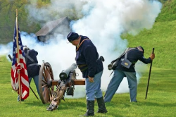 Harpers Ferry became a hub for travelers and traders because of the arrival of the Chesapeake & Ohio Canal and the Baltimore & Ohio Railroad. Even George Washington recognized the town’s strategic potential. He proposed Harpers Ferry as the location for the United States Armory and Arsenal back in 1794. Just 65 years later, that very U.S. Armory and Arsenal catapulted Harpers Ferry to national notoriety when it was the target of an infamous raid led by abolitionist John Brown.
Over the next few years after Brown’s attack, Harpers Ferry’s Armory and Arsenal became a regular battleground in the Civil War between the Union and the Confederacy. The early turmoil in Harpers Ferry was a wartime foreshadowing— over the course of the 4-year conflict, the town changed hands 8 times.
Of all the towering cliffs surrounding Harpers Ferry, Maryland Heights provided the best defense— a devastating lesson that Union commanders quickly learned firsthand. Just a few months into the war, a group of Virginia militiamen commanded by  Colonel T.J. “Stonewall” Jackson briefly occupied Bolivar Heights in April 1861, but Brigadier General Joseph E. Johnston evacuated the town in June. When Union troops reclaimed Harpers Ferry, they considered the strategic bluffs too rugged to heavily fortify.
But by May 1862, as Jackson’s Valley Campaign ramped up, Union troops hastened to build the first strategic defense on Maryland Heights— a battery situated on a lofty clearing overlooking the town, armed with two 9-inch Dahlgren naval guns and 50-pounder. This was enough firepower to cover Harpers Ferry, Loudoun Heights and Bolivar Heights.
But Northern defenses of the town were inadequate, and ultimately not enough to offset their vast inexperience. Union commander Dixon Miles not only failed to fortify most of the bluffs cradling Harpers Ferry, but as 3 separate columns of Confederate troops barreled toward Harpers Ferry in September 1862, he also concentrated his soldiers near the town, sending only 1 brigade to Maryland Heights, and leaving Loudon Heights undefended.Confederate Major General Lafayette McLaws easily claimed Maryland Heights.
Just 2 days later, Miles was forced to cede Harpers Ferry altogether, leading to the surrender of more than 12,000 Union soldiers— the single largest capture of Federal soldiers of the entire war.
Maryland Heights Trail
When Union troops reclaimed Harpers Ferry following the Battle of Antietam, commanders were quick to learn from earlier mistakes. They immediately  began fortifying Maryland Heights, transforming the landscape. Traces of their occupation are still visible today. The stone foundations and tent pads they carved into the earth for military camps still dot the Maryland Heights Trail, along with remnants from a number of the Union army’s other defenses.
Look for the 30-pound battery adjacent to the trail. During the war, it was loaded with 6 Parrott rifles, which were capable of firing on both Loudon Heights and Bolivar Heights. In the fall of 1862, Union troops also started construction on the most elaborate fortification along the historic trail: the unfinished Stone Fort atop Maryland Heights’ 1,448-foot pinnacle.
There were expansive rock walls with openings for Parrott rifles, and further down the trail was the 100-pound battery, which was armed with a Dahlgren gun that weighed nearly 10,000 pounds.
Beyond the embellishments the Union soldiers made to Maryland Heights more than 150 years ago, the trail itself is also part of Harpers Ferry’s history. Locals used its pathways to turn the woodlands into charcoal, then the thoroughfares lacing Maryland Heights were converted into military roads. Wagons rattled over them, hauling cache after cache of Union artillery.
Today on the Maryland Heights Trail, cannon fire has been replaced by more subtle sounds— the wind rippling through the trees and the crunch of gravel underfoot. But standing atop the bluffs overlooking Harpers Ferry, it’s easy to imagine the countless soldiers positioned on the very same cliff, keeping a vigilant watch on the town below.
Maryland Heights Trail is only one of several historic hikes in Harpers Ferry.
This post was last updated on March 16, 2022